


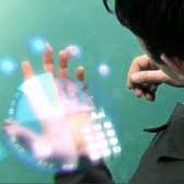
Point cloud video has been widely used by augmented reality (AR) and virtual reality (VR) applications as it allows users to have an immersive experience of six degrees of freedom (6DoFs). Yet there is still a lack of research on quality of experience (QoE) model of point cloud video streaming, which cannot provide optimization metric for streaming systems. Besides, position and color information contained in each pixel of point cloud video, and viewport distance effect caused by 6DoFs viewing procedure make the traditional objective quality evaluation metric cannot be directly used in point cloud video streaming system. In this paper we first analyze the subjective and objective factors related to QoE model. Then an experimental system to simulate point cloud video streaming is setup and detailed subjective quality evaluation experiments are carried out. Based on collected mean opinion score (MOS) data, we propose a QoE model for point cloud video streaming. We also verify the model by actual subjective scoring, and the results show that the proposed QoE model can accurately reflect users' visual perception. We also make the experimental database public to promote the QoE research of point cloud video streaming.
相關內容
Media streaming has been adopted for a variety of applications such as entertainment, visualization, and design. Unlike video/audio streaming where the content is usually consumed sequentially, 3D applications such as gaming require streaming 3D assets to facilitate client-side interactions such as object manipulation and viewpoint movement. Compared to audio and video streaming, 3D streaming often requires larger data sizes and yet lower latency to ensure sufficient rendering quality, resolution, and latency for perceptual comfort. Thus, streaming 3D assets can be even more challenging than streaming audios/videos, and existing solutions often suffer from long loading time or limited quality. To address this critical and timely issue, we propose a perceptually-optimized progressive 3D streaming method for spatial quality and temporal consistency in immersive interactions. Based on the human visual mechanisms in the frequency domain, our model selects and schedules the streaming dataset for optimal spatial-temporal quality. We also train a neural network for our model to accelerate this decision process for real-time client-server applications. We evaluate our method via subjective studies and objective analysis under varying network conditions (from 3G to 5G) and client devices (HMD and traditional displays), and demonstrate better visual quality and temporal consistency than alternative solutions.
Nearest neighbor search supports important applications in many domains, such as database, machine learning, computer vision. Since the computational cost for accurate search is too high, the community turned to the research of approximate nearest neighbor search (ANNS). Among them, graph-based algorithm is one of the most important branches. Research by Fu et al. shows that the algorithms based on Monotonic Search Network (MSNET), such as NSG and NSSG, have achieved the state-of-the-art search performance in efficiency. The MSNET is dedicated to achieving monotonic search with minimal out-degree of nodes to pursue high efficiency. However, the current MSNET designs did not optimize the probability of the monotonic search, and the lower bound of the probability is only 50%. If they fail in monotonic search stage, they have to suffer tremendous backtracking cost to achieve the required accuracy. This will cause performance problems in search efficiency. To address this problem, we propose (r,p)-MSNET, which achieves guaranteed probability on monotonic search. Due to the high building complexity of a strict (r,p)-MSNET, we propose TBSG, which is an approximation with low complexity. Experiment conducted on four million-scaled datasets show that TBSG outperforms existing state-of-the-art graph-based algorithms in search efficiency. Our code has been released on Github.
Cloud computing is an opened and distributed network that guarantees access to a large amount of data and IT infrastructure at several levels (software, hardware...). With the increase demand, handling clients' needs is getting increasingly challenging. Responding to all requesting clients could lead to security breaches, and since it is the provider's responsibility to secure not only the offered cloud services but also the data, it is important to ensure clients reliability. Although filtering clients in the cloud is not so common, it is required to assure cloud safety. In this paper, by implementing multi agent systems in the cloud to handle interactions for the providers, trust is introduced at agent level to filtrate the clients asking for services by using Particle Swarm Optimization and acquaintance knowledge to determine malicious and untrustworthy clients. The selection depends on previous knowledge and overall rating of trusted peers. The conducted experiments show that the model outputs relevant results, and even with a small number of peers, the framework is able to converge to the best solution. The model presented in this paper is a part of ongoing work to adapt interactions in the cloud.
Dynamic Adaptive Streaming over HTTP(DASH) is becoming the defacto method for effective video traffic delivery at large scale.Its primer success factor returns to the full autonomy given to the streaming clients making them smarter and enabling decentralized logic of video quality decision at granular video chunks following a pull-based paradigm. However,the pure autonomy of the clients inherently results in an overall selfish environment where each client independently strives to improve its Quality of Experience (QoE). Consequently,the clients will hurt each other,including themselves,due to their limited scope of perception.This shortcoming could be addressed by employing a mechanism that has a global view,hence could efficiently manage the available resources.In this paper,we propose a game theoretical-based approach to address the issue of the client's selfishness in multi-server setup,without affecting its autonomy. Particularly,we employ the coalitional game framework to affect the clients to the best server,ultimately to maximize the overall average quality of the clients while preventing re-buffering.We validate our solution through extensive experiments and showcase the effectiveness of the proposed solution.
Lidar-based sensing drives current autonomous vehicles. Despite rapid progress, current Lidar sensors still lag two decades behind traditional color cameras in terms of resolution and cost. For autonomous driving, this means that large objects close to the sensors are easily visible, but far-away or small objects comprise only one measurement or two. This is an issue, especially when these objects turn out to be driving hazards. On the other hand, these same objects are clearly visible in onboard RGB sensors. In this work, we present an approach to seamlessly fuse RGB sensors into Lidar-based 3D recognition. Our approach takes a set of 2D detections to generate dense 3D virtual points to augment an otherwise sparse 3D point cloud. These virtual points naturally integrate into any standard Lidar-based 3D detectors along with regular Lidar measurements. The resulting multi-modal detector is simple and effective. Experimental results on the large-scale nuScenes dataset show that our framework improves a strong CenterPoint baseline by a significant 6.6 mAP, and outperforms competing fusion approaches. Code and more visualizations are available at //tianweiy.github.io/mvp/
In this paper, we focus on the question: how might mobile robots take advantage of affordable RGB-D sensors for object detection? Although current CNN-based object detectors have achieved impressive results, there are three main drawbacks for practical usage on mobile robots: 1) It is hard and time-consuming to collect and annotate large-scale training sets. 2) It usually needs a long training time. 3) CNN-based object detection shows significant weakness in predicting location. We propose a novel approach for the detection of planar objects, which rectifies images with geometric information to compensate for the perspective distortion before feeding it to the CNN detector module, typically a CNN-based detector like YOLO or MASK RCNN. By dealing with the perspective distortion in advance, we eliminate the need for the CNN detector to learn that. Experiments show that this approach significantly boosts the detection performance. Besides, it effectively reduces the number of training images required. In addition to the novel detection framework proposed, we also release an RGB-D dataset for hazmat sign detection. To the best of our knowledge, this is the first public-available hazmat sign detection dataset with RGB-D sensors.
We study the problem of video-to-video synthesis, whose goal is to learn a mapping function from an input source video (e.g., a sequence of semantic segmentation masks) to an output photorealistic video that precisely depicts the content of the source video. While its image counterpart, the image-to-image synthesis problem, is a popular topic, the video-to-video synthesis problem is less explored in the literature. Without understanding temporal dynamics, directly applying existing image synthesis approaches to an input video often results in temporally incoherent videos of low visual quality. In this paper, we propose a novel video-to-video synthesis approach under the generative adversarial learning framework. Through carefully-designed generator and discriminator architectures, coupled with a spatio-temporal adversarial objective, we achieve high-resolution, photorealistic, temporally coherent video results on a diverse set of input formats including segmentation masks, sketches, and poses. Experiments on multiple benchmarks show the advantage of our method compared to strong baselines. In particular, our model is capable of synthesizing 2K resolution videos of street scenes up to 30 seconds long, which significantly advances the state-of-the-art of video synthesis. Finally, we apply our approach to future video prediction, outperforming several state-of-the-art competing systems.
Inferring the 3D geometry and the semantic meaning of surfaces, which are occluded, is a very challenging task. Recently, a first end-to-end learning approach has been proposed that completes a scene from a single depth image. The approach voxelizes the scene and predicts for each voxel if it is occupied and, if it is occupied, the semantic class label. In this work, we propose a two stream approach that leverages depth information and semantic information, which is inferred from the RGB image, for this task. The approach constructs an incomplete 3D semantic tensor, which uses a compact three-channel encoding for the inferred semantic information, and uses a 3D CNN to infer the complete 3D semantic tensor. In our experimental evaluation, we show that the proposed two stream approach substantially outperforms the state-of-the-art for semantic scene completion.
We propose a scalable, efficient and accurate approach to retrieve 3D models for objects in the wild. Our contribution is twofold. We first present a 3D pose estimation approach for object categories which significantly outperforms the state-of-the-art on Pascal3D+. Second, we use the estimated pose as a prior to retrieve 3D models which accurately represent the geometry of objects in RGB images. For this purpose, we render depth images from 3D models under our predicted pose and match learned image descriptors of RGB images against those of rendered depth images using a CNN-based multi-view metric learning approach. In this way, we are the first to report quantitative results for 3D model retrieval on Pascal3D+, where our method chooses the same models as human annotators for 50% of the validation images on average. In addition, we show that our method, which was trained purely on Pascal3D+, retrieves rich and accurate 3D models from ShapeNet given RGB images of objects in the wild.
Cloud Robotics is one of the emerging area of robotics. It has created a lot of attention due to its direct practical implications on Robotics. In Cloud Robotics, the concept of cloud computing is used to offload computational extensive jobs of the robots to the cloud. Apart from this, additional functionalities can also be offered on run to the robots on demand. Simultaneous Localization and Mapping (SLAM) is one of the computational intensive algorithm in robotics used by robots for navigation and map building in an unknown environment. Several Cloud based frameworks are proposed specifically to address the problem of SLAM, DAvinCi, Rapyuta and C2TAM are some of those framework. In this paper, we presented a detailed review of all these framework implementation for SLAM problem.


注冊地址: 北京市海淀區羊坊店路18號2幢3層301-191