

Hyperspectral imaging has been increasingly used for underwater survey applications over the past years. As many hyperspectral cameras work as push-broom scanners, their use is usually limited to the creation of photo-mosaics based on a flat surface approximation and by interpolating the camera pose from dead-reckoning navigation. Yet, because of drift in the navigation and the mostly wrong flat surface assumption, the quality of the obtained photo-mosaics is often too low to support adequate analysis.In this paper we present an initial method for creating hyperspectral 3D reconstructions of underwater environments. By fusing the data gathered by a classical RGB camera, an inertial navigation system and a hyperspectral push-broom camera, we show that the proposed method creates highly accurate 3D reconstructions with hyperspectral textures. We propose to combine techniques from simultaneous localization and mapping, structure-from-motion and 3D reconstruction and advantageously use them to create 3D models with hyperspectral texture, allowing us to overcome the flat surface assumption and the classical limitation of dead-reckoning navigation.
相關內容
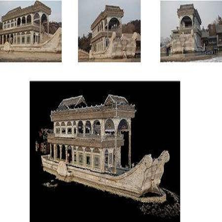
在計算機視覺中, 三維重建是指根據單視圖或者多視圖的圖像重建三維信息的過程. 由于單視頻的信息不完全,因此三維重建需要利用經驗知識. 而多視圖的三維重建(類似人的雙目定位)相對比較容易, 其方法是先對攝像機進行標定, 即計算出攝像機的圖象坐標系與世界坐標系的關系.然后利用多個二維圖象中的信息重建出三維信息。
物體三維重建是計算機輔助幾何設計(CAGD)、計算機圖形學(CG)、計算機動畫、計算機視覺、醫學圖像處理、科學計算和虛擬現實、數字媒體創作等領域的共性科學問題和核心技術。在計算機內生成物體三維表示主要有兩類方法。一類是使用幾何建模軟件通過人機交互生成人為控制下的物體三維幾何模型,另一類是通過一定的手段獲取真實物體的幾何形狀。前者實現技術已經十分成熟,現有若干軟件支持,比如:3DMAX、Maya、AutoCAD、UG等等,它們一般使用具有數學表達式的曲線曲面表示幾何形狀。后者一般稱為三維重建過程,三維重建是指利用二維投影恢復物體三維信息(形狀等)的數學過程和計算機技術,包括數據獲取、預處理、點云拼接和特征分析等步驟。
Neural Radiance Fields (NeRF) have recently gained a surge of interest within the computer vision community for its power to synthesize photorealistic novel views of real-world scenes. One limitation of NeRF, however, is its requirement of accurate camera poses to learn the scene representations. In this paper, we propose Bundle-Adjusting Neural Radiance Fields (BARF) for training NeRF from imperfect (or even unknown) camera poses -- the joint problem of learning neural 3D representations and registering camera frames. We establish a theoretical connection to classical image alignment and show that coarse-to-fine registration is also applicable to NeRF. Furthermore, we show that na\"ively applying positional encoding in NeRF has a negative impact on registration with a synthesis-based objective. Experiments on synthetic and real-world data show that BARF can effectively optimize the neural scene representations and resolve large camera pose misalignment at the same time. This enables view synthesis and localization of video sequences from unknown camera poses, opening up new avenues for visual localization systems (e.g. SLAM) and potential applications for dense 3D mapping and reconstruction.
We present a learning-based approach for removing unwanted obstructions, such as window reflections, fence occlusions or raindrops, from a short sequence of images captured by a moving camera. Our method leverages the motion differences between the background and the obstructing elements to recover both layers. Specifically, we alternate between estimating dense optical flow fields of the two layers and reconstructing each layer from the flow-warped images via a deep convolutional neural network. The learning-based layer reconstruction allows us to accommodate potential errors in the flow estimation and brittle assumptions such as brightness consistency. We show that training on synthetically generated data transfers well to real images. Our results on numerous challenging scenarios of reflection and fence removal demonstrate the effectiveness of the proposed method.
Vision-based Simultaneous Localization And Mapping (VSLAM) is a mature problem in Robotics. Most VSLAM systems are feature based methods, which are robust and present high accuracy, but yield sparse maps with limited application for further navigation tasks. Most recently, direct methods which operate directly on image intensity have been introduced, capable of reconstructing richer maps at the cost of higher processing power. In this work, an edge-based monocular SLAM system (SE-SLAM) is proposed as a middle point: edges present good localization as point features, while enabling a structural semidense map reconstruction. However, edges are not easy to associate, track and optimize over time, as they lack descriptors and biunivocal correspondence, unlike point features. To tackle these issues, this paper presents a method to match edges between frames in a consistent manner; a feasible strategy to solve the optimization problem, since its size rapidly increases when working with edges; and the use of non-linear optimization techniques. The resulting system achieves comparable precision to state of the art feature-based and dense/semi-dense systems, while inherently building a structural semi-dense reconstruction of the environment, providing relevant structure data for further navigation algorithms. To achieve such accuracy, state of the art non-linear optimization is needed, over a continuous feed of 10000 edgepoints per frame, to optimize the full semi-dense output. Despite its heavy processing requirements, the system achieves near to real-time operation, thanks to a custom built solver and parallelization of its key stages. In order to encourage further development of edge-based SLAM systems, SE-SLAM source code will be released as open source.
Convolutions on monocular dash cam videos capture spatial invariances in the image plane but do not explicitly reason about distances and depth. We propose a simple transformation of observations into a bird's eye view, also known as plan view, for end-to-end control. We detect vehicles and pedestrians in the first person view and project them into an overhead plan view. This representation provides an abstraction of the environment from which a deep network can easily deduce the positions and directions of entities. Additionally, the plan view enables us to leverage advances in 3D object detection in conjunction with deep policy learning. We evaluate our monocular plan view network on the photo-realistic Grand Theft Auto V simulator. A network using both a plan view and front view causes less than half as many collisions as previous detection-based methods and an order of magnitude fewer collisions than pure pixel-based policies.
3D image segmentation plays an important role in biomedical image analysis. Many 2D and 3D deep learning models have achieved state-of-the-art segmentation performance on 3D biomedical image datasets. Yet, 2D and 3D models have their own strengths and weaknesses, and by unifying them together, one may be able to achieve more accurate results. In this paper, we propose a new ensemble learning framework for 3D biomedical image segmentation that combines the merits of 2D and 3D models. First, we develop a fully convolutional network based meta-learner to learn how to improve the results from 2D and 3D models (base-learners). Then, to minimize over-fitting for our sophisticated meta-learner, we devise a new training method that uses the results of the base-learners as multiple versions of "ground truths". Furthermore, since our new meta-learner training scheme does not depend on manual annotation, it can utilize abundant unlabeled 3D image data to further improve the model. Extensive experiments on two public datasets (the HVSMR 2016 Challenge dataset and the mouse piriform cortex dataset) show that our approach is effective under fully-supervised, semi-supervised, and transductive settings, and attains superior performance over state-of-the-art image segmentation methods.
This paper implements Simultaneous Localization and Mapping (SLAM) technique to construct a map of a given environment. A Real Time Appearance Based Mapping (RTAB-Map) approach was taken for accomplishing this task. Initially, a 2d occupancy grid and 3d octomap was created from a provided simulated environment. Next, a personal simulated environment was created for mapping as well. In this appearance based method, a process called Loop Closure is used to determine whether a robot has seen a location before or not. In this paper, it is seen that RTAB-Map is optimized for large scale and long term SLAM by using multiple strategies to allow for loop closure to be done in real time and the results depict that it can be an excellent solution for SLAM to develop robots that can map an environment in both 2d and 3d.
Higher level functionality in autonomous driving depends strongly on a precise motion estimate of the vehicle. Powerful algorithms have been developed. However, their great majority focuses on either binocular imagery or pure LIDAR measurements. The promising combination of camera and LIDAR for visual localization has mostly been unattended. In this work we fill this gap, by proposing a depth extraction algorithm from LIDAR measurements for camera feature tracks and estimating motion by robustified keyframe based Bundle Adjustment. Semantic labeling is used for outlier rejection and weighting of vegetation landmarks. The capability of this sensor combination is demonstrated on the competitive KITTI dataset, achieving a placement among the top 15. The code is released to the community.
The robust and efficient recognition of visual relations in images is a hallmark of biological vision. Here, we argue that, despite recent progress in visual recognition, modern machine vision algorithms are severely limited in their ability to learn visual relations. Through controlled experiments, we demonstrate that visual-relation problems strain convolutional neural networks (CNNs). The networks eventually break altogether when rote memorization becomes impossible such as when the intra-class variability exceeds their capacity. We further show that another type of feedforward network, called a relational network (RN), which was shown to successfully solve seemingly difficult visual question answering (VQA) problems on the CLEVR datasets, suffers similar limitations. Motivated by the comparable success of biological vision, we argue that feedback mechanisms including working memory and attention are the key computational components underlying abstract visual reasoning.
High spectral dimensionality and the shortage of annotations make hyperspectral image (HSI) classification a challenging problem. Recent studies suggest that convolutional neural networks can learn discriminative spatial features, which play a paramount role in HSI interpretation. However, most of these methods ignore the distinctive spectral-spatial characteristic of hyperspectral data. In addition, a large amount of unlabeled data remains an unexploited gold mine for efficient data use. Therefore, we proposed an integration of generative adversarial networks (GANs) and probabilistic graphical models for HSI classification. Specifically, we used a spectral-spatial generator and a discriminator to identify land cover categories of hyperspectral cubes. Moreover, to take advantage of a large amount of unlabeled data, we adopted a conditional random field to refine the preliminary classification results generated by GANs. Experimental results obtained using two commonly studied datasets demonstrate that the proposed framework achieved encouraging classification accuracy using a small number of data for training.
Hyperspectral imaging holds enormous potential to improve the state-of-the-art in aerial vehicle tracking with low spatial and temporal resolutions. Recently, adaptive multi-modal hyperspectral sensors, controlled by Dynamic Data Driven Applications Systems (DDDAS) methodology, have attracted growing interest due to their ability to record extended data quickly from the aerial platforms. In this study, we apply popular concepts from traditional object tracking - (1) Kernelized Correlation Filters (KCF) and (2) Deep Convolutional Neural Network (CNN) features - to the hyperspectral aerial tracking domain. Specifically, we propose the Deep Hyperspectral Kernelized Correlation Filter based tracker (DeepHKCF) to efficiently track aerial vehicles using an adaptive multi-modal hyperspectral sensor. We address low temporal resolution by designing a single KCF-in-multiple Regions-of-Interest (ROIs) approach to cover a reasonable large area. To increase the speed of deep convolutional features extraction from multiple ROIs, we design an effective ROI mapping strategy. The proposed tracker also provides flexibility to couple it to the more advanced correlation filter trackers. The DeepHKCF tracker performs exceptionally with deep features set up in a synthetic hyperspectral video generated by the Digital Imaging and Remote Sensing Image Generation (DIRSIG) software. Additionally, we generate a large, synthetic, single-channel dataset using DIRSIG to perform vehicle classification in the Wide Area Motion Imagery (WAMI) platform . This way, the high-fidelity of the DIRSIG software is proved and a large scale aerial vehicle classification dataset is released to support studies on vehicle detection and tracking in the WAMI platform.
小貼士
登錄享
相關主題


注冊地址: 北京市海淀區羊坊店路18號2幢3層301-191