

The recent trend in multiple object tracking (MOT) is jointly solving detection and tracking, where object detection and appearance feature (or motion) are learned simultaneously. Despite competitive performance, in crowded scenes, joint detection and tracking usually fail to find accurate object associations due to missed or false detections. In this paper, we jointly model counting, detection and re-identification in an end-to-end framework, named CountingMOT, tailored for crowded scenes. By imposing mutual object-count constraints between detection and counting, the CountingMOT tries to find a balance between object detection and crowd density map estimation, which can help it to recover missed detections or reject false detections. Our approach is an attempt to bridge the gap of object detection, counting, and re-Identification. This is in contrast to prior MOT methods that either ignore the crowd density and thus are prone to failure in crowded scenes, or depend on local correlations to build a graphical relationship for matching targets. The proposed MOT tracker can perform online and real-time tracking, and achieves the state-of-the-art results on public benchmarks MOT16 (MOTA of 79.7), MOT17 (MOTA of 81.3%) and MOT20 (MOTA of 78.9%).
相關內容
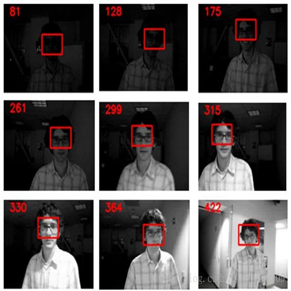
標跟蹤是指:給出目標在跟蹤視頻第一幀中的初始狀態(如位置,尺寸),自動估計目標物體在后續幀中的狀態。
目標跟蹤分為單目標跟蹤和多目標跟蹤。
人眼可以比較輕松的在一段時間內跟住某個特定目標。但是對機器而言,這一任務并不簡單,尤其是跟蹤過程中會出現目標發生劇烈形變、被其他目標遮擋或出現相似物體干擾等等各種復雜的情況。過去幾十年以來,目標跟蹤的研究取得了長足的發展,尤其是各種機器學習算法被引入以來,目標跟蹤算法呈現百花齊放的態勢。2013年以來,深度學習方法開始在目標跟蹤領域展露頭腳,并逐漸在性能上超越傳統方法,取得巨大的突破。
Detecting changes that occurred in a pair of 3D airborne LiDAR point clouds, acquired at two different times over the same geographical area, is a challenging task because of unmatching spatial supports and acquisition system noise. Most recent attempts to detect changes on point clouds are based on supervised methods, which require large labelled data unavailable in real-world applications. To address these issues, we propose an unsupervised approach that comprises two components: Neural Field (NF) for continuous shape reconstruction and a Gaussian Mixture Model for categorising changes. NF offer a grid-agnostic representation to encode bi-temporal point clouds with unmatched spatial support that can be regularised to increase high-frequency details and reduce noise. The reconstructions at each timestamp are compared at arbitrary spatial scales, leading to a significant increase in detection capabilities. We apply our method to a benchmark dataset of simulated LiDAR point clouds for urban sprawling. The dataset offers different challenging scenarios with different resolutions, input modalities and noise levels, allowing a multi-scenario comparison of our method with the current state-of-the-art. We boast the previous methods on this dataset by a 10% margin in intersection over union metric. In addition, we apply our methods to a real-world scenario to identify illegal excavation (looting) of archaeological sites and confirm that they match findings from field experts.
Fully-unsupervised Person and Vehicle Re-Identification have received increasing attention due to their broad applicability in surveillance, forensics, event understanding, and smart cities, without requiring any manual annotation. However, most of the prior art has been evaluated in datasets that have just a couple thousand samples. Such small-data setups often allow the use of costly techniques in time and memory footprints, such as Re-Ranking, to improve clustering results. Moreover, some previous work even pre-selects the best clustering hyper-parameters for each dataset, which is unrealistic in a large-scale fully-unsupervised scenario. In this context, this work tackles a more realistic scenario and proposes two strategies to learn from large-scale unlabeled data. The first strategy performs a local neighborhood sampling to reduce the dataset size in each iteration without violating neighborhood relationships. A second strategy leverages a novel Re-Ranking technique, which has a lower time upper bound complexity and reduces the memory complexity from O(n^2) to O(kn) with k << n. To avoid the pre-selection of specific hyper-parameter values for the clustering algorithm, we also present a novel scheduling algorithm that adjusts the density parameter during training, to leverage the diversity of samples and keep the learning robust to noisy labeling. Finally, due to the complementary knowledge learned by different models, we also introduce a co-training strategy that relies upon the permutation of predicted pseudo-labels, among the backbones, with no need for any hyper-parameters or weighting optimization. The proposed methodology outperforms the state-of-the-art methods in well-known benchmarks and in the challenging large-scale Veri-Wild dataset, with a faster and memory-efficient Re-Ranking strategy, and a large-scale, noisy-robust, and ensemble-based learning approach.
In many visual systems, visual tracking often bases on RGB image sequences, in which some targets are invalid in low-light conditions, and tracking performance is thus affected significantly. Introducing other modalities such as depth and infrared data is an effective way to handle imaging limitations of individual sources, but multi-modal imaging platforms usually require elaborate designs and cannot be applied in many real-world applications at present. Near-infrared (NIR) imaging becomes an essential part of many surveillance cameras, whose imaging is switchable between RGB and NIR based on the light intensity. These two modalities are heterogeneous with very different visual properties and thus bring big challenges for visual tracking. However, existing works have not studied this challenging problem. In this work, we address the cross-modal object tracking problem and contribute a new video dataset, including 654 cross-modal image sequences with over 481K frames in total, and the average video length is more than 735 frames. To promote the research and development of cross-modal object tracking, we propose a new algorithm, which learns the modality-aware target representation to mitigate the appearance gap between RGB and NIR modalities in the tracking process. It is plug-and-play and could thus be flexibly embedded into different tracking frameworks. Extensive experiments on the dataset are conducted, and we demonstrate the effectiveness of the proposed algorithm in two representative tracking frameworks against 17 state-of-the-art tracking methods. We will release the dataset for free academic usage, dataset download link and code will be released soon.
Owing to effective and flexible data acquisition, unmanned aerial vehicle (UAV) has recently become a hotspot across the fields of computer vision (CV) and remote sensing (RS). Inspired by recent success of deep learning (DL), many advanced object detection and tracking approaches have been widely applied to various UAV-related tasks, such as environmental monitoring, precision agriculture, traffic management. This paper provides a comprehensive survey on the research progress and prospects of DL-based UAV object detection and tracking methods. More specifically, we first outline the challenges, statistics of existing methods, and provide solutions from the perspectives of DL-based models in three research topics: object detection from the image, object detection from the video, and object tracking from the video. Open datasets related to UAV-dominated object detection and tracking are exhausted, and four benchmark datasets are employed for performance evaluation using some state-of-the-art methods. Finally, prospects and considerations for the future work are discussed and summarized. It is expected that this survey can facilitate those researchers who come from remote sensing field with an overview of DL-based UAV object detection and tracking methods, along with some thoughts on their further developments.
Unsupervised domain adaptation (UDA) methods for person re-identification (re-ID) aim at transferring re-ID knowledge from labeled source data to unlabeled target data. Although achieving great success, most of them only use limited data from a single-source domain for model pre-training, making the rich labeled data insufficiently exploited. To make full use of the valuable labeled data, we introduce the multi-source concept into UDA person re-ID field, where multiple source datasets are used during training. However, because of domain gaps, simply combining different datasets only brings limited improvement. In this paper, we try to address this problem from two perspectives, \ie{} domain-specific view and domain-fusion view. Two constructive modules are proposed, and they are compatible with each other. First, a rectification domain-specific batch normalization (RDSBN) module is explored to simultaneously reduce domain-specific characteristics and increase the distinctiveness of person features. Second, a graph convolutional network (GCN) based multi-domain information fusion (MDIF) module is developed, which minimizes domain distances by fusing features of different domains. The proposed method outperforms state-of-the-art UDA person re-ID methods by a large margin, and even achieves comparable performance to the supervised approaches without any post-processing techniques.
Correlation acts as a critical role in the tracking field, especially in recent popular Siamese-based trackers. The correlation operation is a simple fusion manner to consider the similarity between the template and the search region. However, the correlation operation itself is a local linear matching process, leading to lose semantic information and fall into local optimum easily, which may be the bottleneck of designing high-accuracy tracking algorithms. Is there any better feature fusion method than correlation? To address this issue, inspired by Transformer, this work presents a novel attention-based feature fusion network, which effectively combines the template and search region features solely using attention. Specifically, the proposed method includes an ego-context augment module based on self-attention and a cross-feature augment module based on cross-attention. Finally, we present a Transformer tracking (named TransT) method based on the Siamese-like feature extraction backbone, the designed attention-based fusion mechanism, and the classification and regression head. Experiments show that our TransT achieves very promising results on six challenging datasets, especially on large-scale LaSOT, TrackingNet, and GOT-10k benchmarks. Our tracker runs at approximatively 50 fps on GPU. Code and models are available at //github.com/chenxin-dlut/TransT.
Object tracking is challenging as target objects often undergo drastic appearance changes over time. Recently, adaptive correlation filters have been successfully applied to object tracking. However, tracking algorithms relying on highly adaptive correlation filters are prone to drift due to noisy updates. Moreover, as these algorithms do not maintain long-term memory of target appearance, they cannot recover from tracking failures caused by heavy occlusion or target disappearance in the camera view. In this paper, we propose to learn multiple adaptive correlation filters with both long-term and short-term memory of target appearance for robust object tracking. First, we learn a kernelized correlation filter with an aggressive learning rate for locating target objects precisely. We take into account the appropriate size of surrounding context and the feature representations. Second, we learn a correlation filter over a feature pyramid centered at the estimated target position for predicting scale changes. Third, we learn a complementary correlation filter with a conservative learning rate to maintain long-term memory of target appearance. We use the output responses of this long-term filter to determine if tracking failure occurs. In the case of tracking failures, we apply an incrementally learned detector to recover the target position in a sliding window fashion. Extensive experimental results on large-scale benchmark datasets demonstrate that the proposed algorithm performs favorably against the state-of-the-art methods in terms of efficiency, accuracy, and robustness.
In this paper, we present a new method for detecting road users in an urban environment which leads to an improvement in multiple object tracking. Our method takes as an input a foreground image and improves the object detection and segmentation. This new image can be used as an input to trackers that use foreground blobs from background subtraction. The first step is to create foreground images for all the frames in an urban video. Then, starting from the original blobs of the foreground image, we merge the blobs that are close to one another and that have similar optical flow. The next step is extracting the edges of the different objects to detect multiple objects that might be very close (and be merged in the same blob) and to adjust the size of the original blobs. At the same time, we use the optical flow to detect occlusion of objects that are moving in opposite directions. Finally, we make a decision on which information we keep in order to construct a new foreground image with blobs that can be used for tracking. The system is validated on four videos of an urban traffic dataset. Our method improves the recall and precision metrics for the object detection task compared to the vanilla background subtraction method and improves the CLEAR MOT metrics in the tracking tasks for most videos.
Object detection is an important and challenging problem in computer vision. Although the past decade has witnessed major advances in object detection in natural scenes, such successes have been slow to aerial imagery, not only because of the huge variation in the scale, orientation and shape of the object instances on the earth's surface, but also due to the scarcity of well-annotated datasets of objects in aerial scenes. To advance object detection research in Earth Vision, also known as Earth Observation and Remote Sensing, we introduce a large-scale Dataset for Object deTection in Aerial images (DOTA). To this end, we collect $2806$ aerial images from different sensors and platforms. Each image is of the size about 4000-by-4000 pixels and contains objects exhibiting a wide variety of scales, orientations, and shapes. These DOTA images are then annotated by experts in aerial image interpretation using $15$ common object categories. The fully annotated DOTA images contains $188,282$ instances, each of which is labeled by an arbitrary (8 d.o.f.) quadrilateral To build a baseline for object detection in Earth Vision, we evaluate state-of-the-art object detection algorithms on DOTA. Experiments demonstrate that DOTA well represents real Earth Vision applications and are quite challenging.
Person Re-identification (re-id) faces two major challenges: the lack of cross-view paired training data and learning discriminative identity-sensitive and view-invariant features in the presence of large pose variations. In this work, we address both problems by proposing a novel deep person image generation model for synthesizing realistic person images conditional on pose. The model is based on a generative adversarial network (GAN) and used specifically for pose normalization in re-id, thus termed pose-normalization GAN (PN-GAN). With the synthesized images, we can learn a new type of deep re-id feature free of the influence of pose variations. We show that this feature is strong on its own and highly complementary to features learned with the original images. Importantly, we now have a model that generalizes to any new re-id dataset without the need for collecting any training data for model fine-tuning, thus making a deep re-id model truly scalable. Extensive experiments on five benchmarks show that our model outperforms the state-of-the-art models, often significantly. In particular, the features learned on Market-1501 can achieve a Rank-1 accuracy of 68.67% on VIPeR without any model fine-tuning, beating almost all existing models fine-tuned on the dataset.
小貼士
登錄享

注冊地址: 北京市海淀區羊坊店路18號2幢3層301-191