


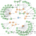
Knowledge representation (KR) is vital in designing symbolic notations to represent real-world facts and facilitate automated decision-making tasks. Knowledge graphs (KGs) have emerged so far as a popular form of KR, offering a contextual and human-like representation of knowledge. In international economics, KGs have proven valuable in capturing complex interactions between commodities, companies, and countries. By putting the gravity model, which is a common economic framework, into the process of building KGs, important factors that affect trade relationships can be taken into account, making it possible to predict international trade patterns. This paper proposes an approach that leverages Knowledge Graph embeddings for modeling international trade, focusing on link prediction using embeddings. Thus, valuable insights are offered to policymakers, businesses, and economists, enabling them to anticipate the effects of changes in the international trade system. Moreover, the integration of traditional machine learning methods with KG embeddings, such as decision trees and graph neural networks are also explored. The research findings demonstrate the potential for improving prediction accuracy and provide insights into embedding explainability in knowledge representation. The paper also presents a comprehensive analysis of the influence of embedding methods on other intelligent algorithms.
相關內容
通過(guo)學(xue)習(xi)、實踐或探索所獲得的認識、判斷或技能。
Ensuring the safety, quality, and timely completion of construction projects is paramount, with construction inspections serving as a vital instrument towards these goals. Nevertheless, the predominantly manual approach of present-day inspections frequently results in inefficiencies and inadequate information management. Such methods often fall short of providing holistic, exhaustive assessments, consequently engendering regulatory oversights and potential safety hazards. To address this issue, this paper presents a novel framework named AutoRepo for automated generation of construction inspection reports. The unmanned vehicles efficiently perform construction inspections and collect scene information, while the multimodal large language models (LLMs) are leveraged to automatically generate the inspection reports. The framework was applied and tested on a real-world construction site, demonstrating its potential to expedite the inspection process, significantly reduce resource allocation, and produce high-quality, regulatory standard-compliant inspection reports. This research thus underscores the immense potential of multimodal large language models in revolutionizing construction inspection practices, signaling a significant leap forward towards a more efficient and safer construction management paradigm.
In this series of studies, we establish homogenized lattice Boltzmann methods (HLBM) for simulating fluid flow through porous media. Our contributions in part I are twofold. First, we assemble the targeted partial differential equation system by formally unifying the governing equations for nonstationary fluid flow in porous media. A matrix of regularly arranged, equally sized obstacles is placed into the domain to model fluid flow through porous structures governed by the incompressible nonstationary Navier--Stokes equations (NSE). Depending on the ratio of geometric parameters in the matrix arrangement, several homogenized equations are obtained. We review existing methods for homogenizing the nonstationary NSE for specific porosities and discuss the applicability of the resulting model equations. Consequently, the homogenized NSE are expressed as targeted partial differential equations that jointly incorporate the derived aspects. Second, we propose a kinetic model, the homogenized Bhatnagar--Gross--Krook Boltzmann equation, which approximates the homogenized nonstationary NSE. We formally prove that the zeroth and first order moments of the kinetic model provide solutions to the mass and momentum balance variables of the macrocopic model up to specific orders in the scaling parameter. Based on the present contributions, in the sequel (part II), the homogenized NSE are consistently approximated by deriving a limit consistent HLBM discretization of the homogenized Bhatnagar--Gross--Krook Boltzmann equation.
Ecosystems are ubiquitous but trust within them is not guaranteed. Trust is paramount because stakeholders within an ecosystem must collaborate to achieve their objectives. With the twin transitions, digital transformation to go in parallel with green transition, accelerating the deployment of autonomous systems, trust has become even more critical to ensure that the deployed technology creates value. To address this need, we propose an ecosystem of trust approach to support deployment of technology by enabling trust among and between stakeholders, technologies and infrastructures, institutions and governance, and the artificial and natural environments in an ecosystem. The approach can help the stakeholders in the ecosystem to create, deliver, and receive value by addressing their concerns and aligning their objectives. We present an autonomous, zero emission ferry as a real world use case to demonstrate the approach from a stakeholder perspective. We argue that assurance, defined as grounds for justified confidence originated from evidence and knowledge, is a prerequisite to enable the approach. Assurance provides evidence and knowledge that are collected, analysed, and communicated in a systematic, targeted, and meaningful way. Assurance can enable the approach to help successfully deploy technology by ensuring that risk is managed, trust is shared, and value is created.
Curb detection is essential for environmental awareness in Automated Driving (AD), as it typically limits drivable and non-drivable areas. Annotated data are necessary for developing and validating an AD function. However, the number of public datasets with annotated point cloud curbs is scarce. This paper presents a method for detecting 3D curbs in a sequence of point clouds captured from a LiDAR sensor, which consists of two main steps. First, our approach detects the curbs at each scan using a segmentation deep neural network. Then, a sequence-level processing step estimates the 3D curbs in the reconstructed point cloud using the odometry of the vehicle. From these 3D points of the curb, we obtain polylines structured following ASAM OpenLABEL standard. These detections can be used as pre-annotations in labelling pipelines to efficiently generate curb-related ground truth data. We validate our approach through an experiment in which different human annotators were required to annotate curbs in a group of LiDAR-based sequences with and without our automatically generated pre-annotations. The results show that the manual annotation time is reduced by 50.99% thanks to our detections, keeping the data quality level.
Presentation of folded documents is not an uncommon case in modern society. Digitizing such documents by capturing them with a smartphone camera can be tricky since a crease can divide the document contents into separate planes. To unfold the document, one could hold the edges potentially obscuring it in a captured image. While there are many geometrical rectification methods, they were usually developed for arbitrary bends and folds. We consider such algorithms and propose a novel approach Unfolder developed specifically for images of documents with a crease from folding in half. Unfolder is robust to projective distortions of the document image and does not fragment the image in the vicinity of a crease after rectification. A new Folded Document Images dataset was created to investigate the rectification accuracy of folded (2, 3, 4, and 8 folds) documents. The dataset includes 1600 images captured when document placed on a table and when held in hand. The Unfolder algorithm allowed for a recognition error rate of 0.33, which is better than the advanced neural network methods DocTr (0.44) and DewarpNet (0.57). The average runtime for Unfolder was only 0.25 s/image on an iPhone XR.
We propose an innovative and generic methodology to analyse individual and collective behaviour through individual trajectory data. The work is motivated by the analysis of GPS trajectories of fishing vessels collected from regulatory tracking data in the context of marine biodiversity conservation and ecosystem-based fisheries management. We build a low-dimensional latent representation of trajectories using convolutional neural networks as non-linear mapping. This is done by training a conditional variational auto-encoder taking into account covariates. The posterior distributions of the latent representations can be linked to the characteristics of the actual trajectories. The latent distributions of the trajectories are compared with the Bhattacharyya coefficient, which is well-suited for comparing distributions. Using this coefficient, we analyse the variation of the individual behaviour of each vessel during time. For collective behaviour analysis, we build proximity graphs and use an extension of the stochastic block model for multiple networks. This model results in a clustering of the individuals based on their set of trajectories. The application to French fishing vessels enables us to obtain groups of vessels whose individual and collective behaviours exhibit spatio-temporal patterns over the period 2014-2018.
To understand high precision observations of exoplanets and brown dwarfs, we need detailed and complex general circulation models (GCMs) that incorporate hydrodynamics, chemistry, and radiation. In this study, we specifically examine the coupling between chemistry and radiation in GCMs and compare different methods for mixing opacities of different chemical species in the correlated-k assumption, when equilibrium chemistry cannot be assumed. We propose a fast machine learning method based on DeepSets (DS), which effectively combines individual correlated-k opacities (k-tables). We evaluate the DS method alongside other published methods like adaptive equivalent extinction (AEE) and random overlap with rebinning and resorting (RORR). We integrate these mixing methods into our GCM (expeRT/MITgcm) and assess their accuracy and performance for the example of the hot Jupiter HD~209458 b. Our findings indicate that the DS method is both accurate and efficient for GCM usage, whereas RORR is too slow. Additionally, we observe that the accuracy of AEE depends on its specific implementation and may introduce numerical issues in achieving radiative transfer solution convergence. We then apply the DS mixing method in a simplified chemical disequilibrium situation, where we model the rainout of TiO and VO, and confirm that the rainout of TiO and VO would hinder the formation of a stratosphere. To further expedite the development of consistent disequilibrium chemistry calculations in GCMs, we provide documentation and code for coupling the DS mixing method with correlated-k radiative transfer solvers. The DS method has been extensively tested to be accurate enough for GCMs, however, other methods might be needed for accelerating atmospheric retrievals.
The trace plot is seldom used in meta-analysis, yet it is a very informative plot. In this article we define and illustrate what the trace plot is, and discuss why it is important. The Bayesian version of the plot combines the posterior density of tau, the between-study standard deviation, and the shrunken estimates of the study effects as a function of tau. With a small or moderate number of studies, tau is not estimated with much precision, and parameter estimates and shrunken study effect estimates can vary widely depending on the correct value of tau. The trace plot allows visualization of the sensitivity to tau along with a plot that shows which values of tau are plausible and which are implausible. A comparable frequentist or empirical Bayes version provides similar results. The concepts are illustrated using examples in meta-analysis and meta-regression; implementaton in R is facilitated in a Bayesian or frequentist framework using the bayesmeta and metafor packages, respectively.
Compiling large datasets from published resources, such as archaeological find catalogues presents fundamental challenges: identifying relevant content and manually recording it is a time-consuming, repetitive and error-prone task. For the data to be useful, it must be of comparable quality and adhere to the same recording standards, which is hardly ever the case in archaeology. Here, we present a new data collection method exploiting recent advances in Artificial Intelligence. Our software uses an object detection neural network combined with further classification networks to speed up, automate, and standardise data collection from legacy resources, such as archaeological drawings and photographs in large unsorted PDF files. The AI-assisted workflow detects common objects found in archaeological catalogues, such as graves, skeletons, ceramics, ornaments, stone tools and maps, and spatially relates and analyses these objects on the page to extract real-life attributes, such as the size and orientation of a grave based on the north arrow and the scale. A graphical interface allows for and assists with manual validation. We demonstrate the benefits of this approach by collecting a range of shapes and numerical attributes from richly-illustrated archaeological catalogues, and benchmark it in a real-world experiment with ten users. Moreover, we record geometric whole-outlines through contour detection, an alternative to landmark-based geometric morphometrics not achievable by hand.
We present ResMLP, an architecture built entirely upon multi-layer perceptrons for image classification. It is a simple residual network that alternates (i) a linear layer in which image patches interact, independently and identically across channels, and (ii) a two-layer feed-forward network in which channels interact independently per patch. When trained with a modern training strategy using heavy data-augmentation and optionally distillation, it attains surprisingly good accuracy/complexity trade-offs on ImageNet. We will share our code based on the Timm library and pre-trained models.
小貼士
登錄享
相關主題


注冊地址: 北京市海淀區羊坊店路18號2幢3層301-191