

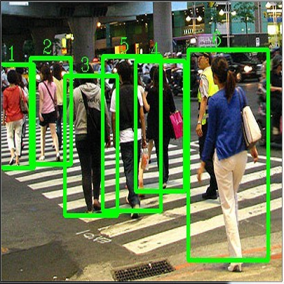
Social distancing in public spaces has become an essential aspect in helping to reduce the impact of the COVID-19 pandemic. Exploiting recent advances in machine learning, there have been many studies in the literature implementing social distancing via object detection through the use of surveillance cameras in public spaces. However, to date, there has been no study of social distance measurement on public transport. The public transport setting has some unique challenges, including some low-resolution images and camera locations that can lead to the partial occlusion of passengers, which make it challenging to perform accurate detection. Thus, in this paper, we investigate the challenges of performing accurate social distance measurement on public transportation. We benchmark several state-of-the-art object detection algorithms using real-world footage taken from the London Underground and bus network. The work highlights the complexity of performing social distancing measurement on images from current public transportation onboard cameras. Further, exploiting domain knowledge of expected passenger behaviour, we attempt to improve the quality of the detections using various strategies and show improvement over using vanilla object detection alone.
相關內容
The table-based fact verification task has recently gained widespread attention and yet remains to be a very challenging problem. It inherently requires informative reasoning over natural language together with different numerical and logical reasoning on tables (e.g., count, superlative, comparative). Considering that, we exploit mixture-of-experts and present in this paper a new method: Self-adaptive Mixture-of-Experts Network (SaMoE). Specifically, we have developed a mixture-of-experts neural network to recognize and execute different types of reasoning -- the network is composed of multiple experts, each handling a specific part of the semantics for reasoning, whereas a management module is applied to decide the contribution of each expert network to the verification result. A self-adaptive method is developed to teach the management module combining results of different experts more efficiently without external knowledge. The experimental results illustrate that our framework achieves 85.1% accuracy on the benchmark dataset TabFact, comparable with the previous state-of-the-art models. We hope our framework can serve as a new baseline for table-based verification. Our code is available at //github.com/THUMLP/SaMoE.
The domain of natural language processing (NLP), which has greatly evolved over the last years, has highly benefited from the recent developments in word and sentence embeddings. Such embeddings enable the transformation of complex NLP tasks, like semantic similarity or Question and Answering (Q&A), into much simpler to perform vector comparisons. However, such a problem transformation raises new challenges like the efficient comparison of embeddings and their manipulation. In this work, we will discuss about various word and sentence embeddings algorithms, we will select a sentence embedding algorithm, BERT, as our algorithm of choice and we will evaluate the performance of two vector comparison approaches, FAISS and Elasticsearch, in the specific problem of sentence embeddings. According to the results, FAISS outperforms Elasticsearch when used in a centralized environment with only one node, especially when big datasets are included.
The shift towards end-to-end deep learning has brought unprecedented advances in many areas of computer vision. However, deep neural networks are trained on images with resolutions that rarely exceed $1,000 \times 1,000$ pixels. The growing use of scanners that create images with extremely high resolutions (average can be $100,000 \times 100,000$ pixels) thereby presents novel challenges to the field. Most of the published methods preprocess high-resolution images into a set of smaller patches, imposing an a priori belief on the best properties of the extracted patches (magnification, field of view, location, etc.). Herein, we introduce Magnifying Networks (MagNets) as an alternative deep learning solution for gigapixel image analysis that does not rely on a preprocessing stage nor requires the processing of billions of pixels. MagNets can learn to dynamically retrieve any part of a gigapixel image, at any magnification level and field of view, in an end-to-end fashion with minimal ground truth (a single global, slide-level label). Our results on the publicly available Camelyon16 and Camelyon17 datasets corroborate to the effectiveness and efficiency of MagNets and the proposed optimization framework for whole slide image classification. Importantly, MagNets process far less patches from each slide than any of the existing approaches ($10$ to $300$ times less).
Multi-camera vehicle tracking is one of the most complicated tasks in Computer Vision as it involves distinct tasks including Vehicle Detection, Tracking, and Re-identification. Despite the challenges, multi-camera vehicle tracking has immense potential in transportation applications including speed, volume, origin-destination (O-D), and routing data generation. Several recent works have addressed the multi-camera tracking problem. However, most of the effort has gone towards improving accuracy on high-quality benchmark datasets while disregarding lower camera resolutions, compression artifacts and the overwhelming amount of computational power and time needed to carry out this task on its edge and thus making it prohibitive for large-scale and real-time deployment. Therefore, in this work we shed light on practical issues that should be addressed for the design of a multi-camera tracking system to provide actionable and timely insights. Moreover, we propose a real-time city-scale multi-camera vehicle tracking system that compares favorably to computationally intensive alternatives and handles real-world, low-resolution CCTV instead of idealized and curated video streams. To show its effectiveness, in addition to integration into the Regional Integrated Transportation Information System (RITIS), we participated in the 2021 NVIDIA AI City multi-camera tracking challenge and our method is ranked among the top five performers on the public leaderboard.
Recent advances in computer vision has led to a growth of interest in deploying visual analytics model on mobile devices. However, most mobile devices have limited computing power, which prohibits them from running large scale visual analytics neural networks. An emerging approach to solve this problem is to offload the computation of these neural networks to computing resources at an edge server. Efficient computation offloading requires optimizing the trade-off between multiple objectives including compressed data rate, analytics performance, and computation speed. In this work, we consider a "split computation" system to offload a part of the computation of the YOLO object detection model. We propose a learnable feature compression approach to compress the intermediate YOLO features with light-weight computation. We train the feature compression and decompression module together with the YOLO model to optimize the object detection accuracy under a rate constraint. Compared to baseline methods that apply either standard image compression or learned image compression at the mobile and perform image decompression and YOLO at the edge, the proposed system achieves higher detection accuracy at the low to medium rate range. Furthermore, the proposed system requires substantially lower computation time on the mobile device with CPU only.
Obtaining a dynamic population distribution is key to many decision-making processes such as urban planning, disaster management and most importantly helping the government to better allocate socio-technical supply. For the aspiration of these objectives, good population data is essential. The traditional method of collecting population data through the census is expensive and tedious. In recent years, machine learning methods have been developed to estimate the population distribution. Most of the methods use data sets that are either developed on a small scale or not publicly available yet. Thus, the development and evaluation of the new methods become challenging. We fill this gap by providing a comprehensive data set for population estimation in 98 European cities. The data set comprises digital elevation model, local climate zone, land use classifications, nighttime lights in combination with multi-spectral Sentinel-2 imagery, and data from the Open Street Map initiative. We anticipate that it would be a valuable addition to the research community for the development of sophisticated machine learning-based approaches in the field of population estimation.
Owing to effective and flexible data acquisition, unmanned aerial vehicle (UAV) has recently become a hotspot across the fields of computer vision (CV) and remote sensing (RS). Inspired by recent success of deep learning (DL), many advanced object detection and tracking approaches have been widely applied to various UAV-related tasks, such as environmental monitoring, precision agriculture, traffic management. This paper provides a comprehensive survey on the research progress and prospects of DL-based UAV object detection and tracking methods. More specifically, we first outline the challenges, statistics of existing methods, and provide solutions from the perspectives of DL-based models in three research topics: object detection from the image, object detection from the video, and object tracking from the video. Open datasets related to UAV-dominated object detection and tracking are exhausted, and four benchmark datasets are employed for performance evaluation using some state-of-the-art methods. Finally, prospects and considerations for the future work are discussed and summarized. It is expected that this survey can facilitate those researchers who come from remote sensing field with an overview of DL-based UAV object detection and tracking methods, along with some thoughts on their further developments.
Humans have a natural instinct to identify unknown object instances in their environments. The intrinsic curiosity about these unknown instances aids in learning about them, when the corresponding knowledge is eventually available. This motivates us to propose a novel computer vision problem called: `Open World Object Detection', where a model is tasked to: 1) identify objects that have not been introduced to it as `unknown', without explicit supervision to do so, and 2) incrementally learn these identified unknown categories without forgetting previously learned classes, when the corresponding labels are progressively received. We formulate the problem, introduce a strong evaluation protocol and provide a novel solution, which we call ORE: Open World Object Detector, based on contrastive clustering and energy based unknown identification. Our experimental evaluation and ablation studies analyze the efficacy of ORE in achieving Open World objectives. As an interesting by-product, we find that identifying and characterizing unknown instances helps to reduce confusion in an incremental object detection setting, where we achieve state-of-the-art performance, with no extra methodological effort. We hope that our work will attract further research into this newly identified, yet crucial research direction.
Detection and recognition of text in natural images are two main problems in the field of computer vision that have a wide variety of applications in analysis of sports videos, autonomous driving, industrial automation, to name a few. They face common challenging problems that are factors in how text is represented and affected by several environmental conditions. The current state-of-the-art scene text detection and/or recognition methods have exploited the witnessed advancement in deep learning architectures and reported a superior accuracy on benchmark datasets when tackling multi-resolution and multi-oriented text. However, there are still several remaining challenges affecting text in the wild images that cause existing methods to underperform due to there models are not able to generalize to unseen data and the insufficient labeled data. Thus, unlike previous surveys in this field, the objectives of this survey are as follows: first, offering the reader not only a review on the recent advancement in scene text detection and recognition, but also presenting the results of conducting extensive experiments using a unified evaluation framework that assesses pre-trained models of the selected methods on challenging cases, and applies the same evaluation criteria on these techniques. Second, identifying several existing challenges for detecting or recognizing text in the wild images, namely, in-plane-rotation, multi-oriented and multi-resolution text, perspective distortion, illumination reflection, partial occlusion, complex fonts, and special characters. Finally, the paper also presents insight into the potential research directions in this field to address some of the mentioned challenges that are still encountering scene text detection and recognition techniques.
Object detection is an important and challenging problem in computer vision. Although the past decade has witnessed major advances in object detection in natural scenes, such successes have been slow to aerial imagery, not only because of the huge variation in the scale, orientation and shape of the object instances on the earth's surface, but also due to the scarcity of well-annotated datasets of objects in aerial scenes. To advance object detection research in Earth Vision, also known as Earth Observation and Remote Sensing, we introduce a large-scale Dataset for Object deTection in Aerial images (DOTA). To this end, we collect $2806$ aerial images from different sensors and platforms. Each image is of the size about 4000-by-4000 pixels and contains objects exhibiting a wide variety of scales, orientations, and shapes. These DOTA images are then annotated by experts in aerial image interpretation using $15$ common object categories. The fully annotated DOTA images contains $188,282$ instances, each of which is labeled by an arbitrary (8 d.o.f.) quadrilateral To build a baseline for object detection in Earth Vision, we evaluate state-of-the-art object detection algorithms on DOTA. Experiments demonstrate that DOTA well represents real Earth Vision applications and are quite challenging.
小貼士
登錄享
相關主題


注冊地址: 北京市海淀區羊坊店路18號2幢3層301-191